 "It all begins with the Map!"
GeoElections News
 Temple Terrace, FL www.icwmaps.com VOL. 14 NO.4 -
  $.50
$.50 Phase 2 - Voting District Project Major Topic At Conference
The Voting District Project, Phase 2 of the 2020 Census Redistricting Data Program, provides states the opportunity to submit to the Census Bureau their voting district boundaries (election precincts, wards, etc.). In Florida, Precincts are primarily built by aggregating Census Blocks with Voter Population attached to each Block. This allows one to keep track of the number of voters per precinct and is consistent with Florida Statute.
In addition, states can submit suggested legal boundary and other geographic area updates. These actions allow states to construct some of the small area geography they need for legislative redistricting. The provided voting districts will be included in the 2020 Census P.L. 94-171 Redistricting Data File tabulations. Participation in Phase 2 of the Redistricting Data Program is conducted through the non-partisan liaison designated by each state. Phase 2 is conducted in three parts. The first two parts are an initial identification of the updates needed with a verification stage to ensure the suggested updates were accurately applied. The third part is a second round of verification for participants who have participated in the first two stages.
• Federal Register Notice - Announcement of Phase 2 [PDF] 213KB
VTD Schedule
• Initial provision of voting districts -- December 2017 through May 31, 2018
• Verification of voting districts 1 -- December 2018 through May 31, 2019
• Verification of voting districts 2 -- December 2019 through March 31, 2020
New Features In GeoPoints©
GeoPoints© includes the MTFCC values for Point Encoding along with Unit Type pick list. Additionally, the GeoElections GeoCoder has been modified as described in the article on the next page. Conflation Layer provides an interface for mapping the fields contained in a point file created by an external agency to the data structure used within GeoPoints. 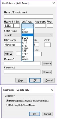 Once the external table has been conflated, the resulting table can be used as a backdrop for building a GeoPoints table. It will also work with the Add Point function within GeoPoints.
 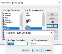 The new GeoPoints – [Unit Types] dialog box allows the user to control the contents of the Unit Type pick list to conform to USPS standards and/or types used in your jurisdiction. The new GeoPoints – [Add Point] and GeoPoints – [Edit Point] dialog boxes provide the user with a Unit Type pick list to minimize data entry errors and standardize with consistent types. The Apartment field is separate and is defined as a string thus storing alpha/numeric values. With the new Update TLID function, one can add a TLID to the records in the GeoPoints table created using the Conflation Layer function. Going to points was never easier.
Users are able to assign tabular values to a table of polygons, Primitive Faces, defining voter districts (VTDs) that each Primitive Face is contained within. The user can also add new lines to a linear network of features (Edges) which are used to define the boundaries of the Primitive Face (polygons). Adding a new line will have the effect of splitting a Primitive Face when the Faces table is regenerated from the Edges.
Finally, after defining the VTDs, the user can run a report function that will aggregate all Faces that share the same values into a VTD map layer and build a table of newly added Edges. After GeoAuthor® VTD Edition builds these two tables, the user will be able to review their work. These two tables are automatically combined into a ZIP file for return to the US Bureau of the Census.
GeoAuthor® has been in use for over a decade with continuous feature updates driven in response to user feature requests and variations in versions of the TIGER/Line Shape Files. For a third decade, ICW is providing a superior technology for participating in this program.
|
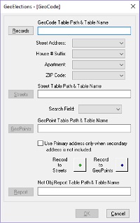
New Control For GeoElections – [GeoCode] Enhancing the functionality of the geocoder in GeoElections to support GeoPoints, ICW has modified the GeoElections – [GeoCode] dialog box to include a new control. The new check box has the following instruction, “Use Primary address only when secondary address is not included”. This new control is illustrated in the dialog box below.
Geocoding with this feature unchecked, voter records with a secondary address designator (SAD) will only match a point with a matching SAD. When this feature is checked, voters with SADs will geocode to points without SADs. When checked, this feature is useful for multiple reasons: 1. In cases when a main address for a multi-residential property exists and you do not have SADs, the voters will geocode to the primary address even if they have SADs in their respective records. this in their info, the voters will geocode.
16th Annual GeoElections Conference 
December 6th, 7th, and 8th, 2017 at the Embassy Suites Hotel located at 10220 Palm River Rd., Tampa, FL 33619. Enjoy workshops and training on topics using GeoElections and GeoAuthor VTD Edition. The GeoElections Conference presents a unique opportunity for elections staff to obtain training in the use of GeoAuthor VTD Edition. Participants will use their own county data as a reference for Census provide VTD Partnership Shapefiles to make the edits for return to the Bureau. Last decade Florida SOEs where given an opportunity to participate in this digital exchange. Our clients used GeoAuthor VTD Edition with great success. The results of their efforts appeared in the 2011 P.L 94-171 TIGER/Line Shape files. This cycle you will see your edits in the 2021 files. We will focus upon Phase II of the Census Data Redistricting Program at the GeoElections Conference. Dinner and Top Golf.
Work hard and plan to enjoy driving off an upper deck. Take your frustrations out on a golf ball with qualified instructors. For more information about the GeoElections Conference visit: www.icwmaps.com and Events>Conferences.
See you in December! |