 "It all begins with the Map!"
GeoElections News
 Temple Terrace, FL www.icwmaps.com VOL. 17 NO.3 -
  $.50
$.50 
Improving the Accuracy of Ballot Assignment
|
GeoElections is geography driven. Using GeoAuthor, Census GIS data along with sources from state and local GIS authorities, can be used to improve the integrity of place. The place a voter resides, which in turn dictates the races and issues for which a voter is entitled to cast a vote. “Some estimate that 10% to 12% of voters in the nation are assigned to the wrong precincts…” 1While all of these voters may not receive ballots that change an outcome in error, how many do receive a ballot that changes an outcome in error? Why should anybody receive a wrong ballot introducing error in the outcome of any election? Would you accept a loss of 10% of the assets in your retirement account? Inflation and opportunity loss may be unavoidable, but mismanagement is unacceptable. Why would an elections official risk distributing wrong ballots to voters when tools are available to conduct the process with the integrity our continuance expect.
GeoElections can programmatically update the VR street index with the accurate GIS data. 1 Wendy Underhill | Vol. 28 No. 3| January 2020, NCSL, “Improving Election Accuracy With GIS Technology”, https://www.ncsl.org/research/elections-and-campaigns/improving-election-accuracy-with-gis-technology.aspx “In close races, every aspect of election procedures will likely be scrutinized, including the assignment of voters.”2 “The state voter registration database has two-thirds of the adult population, so this is your citizen management system,” says Richard Leadbeater of Esri. “This is the start of everything.” The errors, he says, are usually manual: It’s hard to input data accurately. And it’s not possible to do quality control if there is no Geographic Information Systems (GIS) system to compare the data to. So, just the update and correctness of the voter registration files is a huge benefit of moving to GIS-based elections, says Leadbeater. That means using GIS technology in local election offices.”3
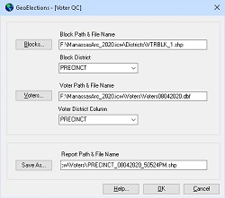
GeoElections provides a complete range of tools for the creation of the highest integrity data. With the base map created including precincts and splits, the user can geocode their voters with the GeoElections GeoCoder. GeoElections has the query capabilities to test the validity of the precinct and/or precinct group assigned to a voter against the values in the base map returning a file of voters out of district. With this information the user can make adjustments to the base map or corrections to the voter registration street index. 2 Same reference as footnote 1 |
|
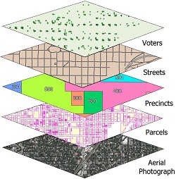
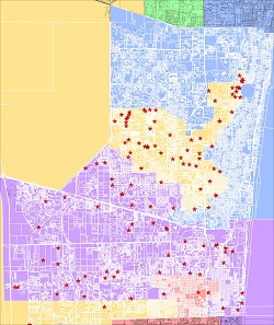
When A Map Is Worth a 1,000 Words Recently an individual seeking placement on a primary ballot to run for a Congressional District in Florida, conducted a petition drive to avoid the Partisan filling fee of $10,440.00. The goal of the petition was Congressional District 22. According to the “2020 Candidate Petition Handbook”, 4,906 signatures are required to qualify as a candidate as a Representative in Congress for District 22. Amongst other conditions to qualify, voters’ signing the petition must reside within the district the petitioner is seeking. Below is a map of Congressional Districts, Census blocks and voters.
A legend for the elements in the map follows: Congressional District 22 spans two counties and this study only illustrates the southern portion of 22. This petition failed by a thin margin and the map clearly illustrates the reason for the failure. This map is worth a thousand words and the SOE in this county was diligent in performing their duties. 19th Annual GeoElections Conference December 9th, 10th, and 11th, 2020 at the Embassy Suites Hotel located at 10220 Palm River Rd., Tampa, FL 33619. Get ready for the new P.L. 94-171 TIGERs. The GeoElections Conference presents a unique opportunity for elections staff to obtain training in the use of GeoAuthor, GeoPoints and GeoElections. Guest speakers are welcomed to speak to a variety of topics related to product solutions and Census data. Meet your counter parts from other counties from Florida and other states. Learn how other professionals solved problems using GeoElections. The GeoElections Conference presents a unique opportunity for elections officials. We focus upon the successful use of GIS in the elections process dictated by the best practices in elections administration. Dinner and Top Golf.
Work hard and plan to enjoy driving off an upper deck. Take your frustrations out on a golf ball with qualified instructors. For more information about the GeoElections Conference visit: www.icwmaps.com and Events>Conferences.
See you in December! |
 The same files your state legislatures will use for redistricting. Also to be presented technical topics using GeoElections. Users should bring their projects on a notebook for a project workshop using your own data.