 "It all begins with the Map!"
GeoElections News
 Temple Terrace, FL www.icwmaps.com VOL. 22 NO. 3 -
  $.50
$.50 
Editing Tools Design for Elections!
|
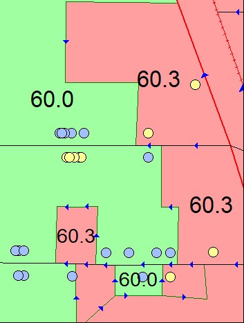
Phase 1 of the Block Boundary Suggestion Project (BBSP), for the 2030 Census Redistricting Data Program (RDP). This is the feature of the process where you can provide data pertinent to redistricting your constituents. Along with the correct precinct assignment you want to be sure everyone has been given the correct assignment. In our illustration to the below, the yellow dots belong to precinct 60.3. There are several voters on the south side of the horizontal street. These are voters that need to be corrected in the voter registration system.
These corrections are made through the voter registration system. Their location is correct. Their precinct assignment must be changed. The next time they are geocoded, they will fall into the correct precinct. This is an error that can be located with regularity.
“Why We Conduct the Decennial Census of Population and Housing The framers of the Constitution of the United States chose population to be the basis for sharing political power, not wealth or land. “Representatives and direct Taxes shall be apportioned among the several States which may be included within this Union, according to their respective Numbers…” - The Constitution of the United States, The census asks questions of people in homes and group living situations, including how many people live or stay in each home, and the sex, age and race of each person. The goal is to count everyone once, only once, and in the right place.”1 GeoAuthor was designed to work with the data formats in the BBSP and VTD data. 1https://www.census.gov/programs-surveys/decennial-census/about/why.html |
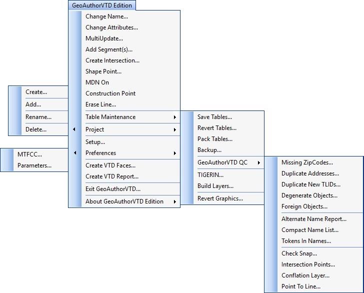
GeoAuthor® Works with Census BBSP and VTD Data It was designed to provide the user with an easy-to-use set of tools with which to create map data for participation in the phases of the BBSP and VTD. The software facilitates the creation of a project for a county or county equivalent using TIGER/Line Shapefiles produced by the US Bureau of the Census for release in January 2025. Here is an expanded view of the menus for GeoAuthor®.
Phase 1 - The Block Boundary Suggestion Project Phase 2 - The Voting District Project Phase 3 - Delivery of the 2030 Census Redistricting Data Phase 4 - Collection of the Post-2030 Census Congressional and State Legislative District Plans Phase 5 - Review of the 2030 Census Redistricting Data Program and Recommendations for the 2040 Census For data call Redistricting Data Program staff at (301) 763-4039 or email rdo@census.gov.
|
Dual Independent Map Encoding (DIME) Give you two nickels for a dime. And now we have the TIGER’s prepared for the 1990 census. Dual Independent Map Encoding (DIME) is an encoding system developed by the U.S. Census Bureau for efficiently storing geographical data and was a key technical development on the "road" toward the geographic information systems (GIS) used today. The development of DIME was assisted by Census Bureau mathematician James Corbett. In 1967, researchers were attempting to convert analog maps into numerically encoded renderings using data from the 1967 pretest of mailout/mail back procedures in New Haven, CT, but found the process to be bogged down by redundant operations. Corbett introduced the basic ideas of the vector paradigm to the programmers who then created a protocol called DIME. Within DIME, intersections, streets, and blocks became analogous to points, lines, and polygons, respectively. The latter group of objects would come to represent the essence of vector data; a structure rooted in Cartesian coordinate geometry. DIME also incorporated the ability to edit topology, a term used to describe the geometric relationships between vector objects. The file format developed for storing DIME-encoded data was known as Geographic Base Files (GBF). GBF-DIME files were digitized for all U.S. cities in the 1970s and provided a schematic map of a city's streets, address ranges, and geostatistical codes relating to the Census Bureau's tabular statistical data. The GBF-DIME files developed in the 1970s and 1980s later became a key component in the development of the Topologically Integrated Geographic Encoding and Referencing (TIGER) system created for the 1990 census. For more information on the development of DIME, see September 6, 1968, Census Bulletin article, "Dime Underwent Lots of Testing Too."2 The TIGERs have been created with the creation of GIS as a discipline. As they move to improve their geographic accuracy, they will continue to enhance the use of as demonstrated by GeoAuthor. |
24th Annual GeoElections Conference December 10th, 11th, and 12th, 2025 at the Embassy Suites Hotel located at 10220 Palm River Rd., Tampa, FL 33619. Get ready for the Census BBSP using 2025 TIGERs. The GeoElections Conference presents a unique opportunity for elections staff to obtain training in the use of GeoAuthor, GeoPoints and GeoElections. Guest speakers are welcome to speak to a variety of topics related to product solutions and Census data. Meet your counter parts from other counties from Florida and other states. Learn how other professionals solve problems using GeoElections. The GeoElections Conference presents a unique opportunity for elections officials. We focus upon the successful use of GIS in the elections process dictated by the best practices in elections administration. Dinner at Top Golf.
Work hard and plan to enjoy driving off an upper deck. Take your frustrations out on a golf ball with qualified instructors. For more information about the GeoElections Conference visit: www.icwmaps.com and Events›Conferences. See you in December! | |
 The same files your state legislature will use for redistricting. Also, technical topics are presented using GeoElections. Users should bring their projects on a notebook for a project workshop using your own data.