GeoElections Expands Integration With Voter Registration
Since the introduction of GeoElections® in 1998,  ICW has worked with voter registration vendors and end-users to provide the integration necessary which to update street indexes, jurisdiction tables, polling place data, and additional information from the GeoElections® project.
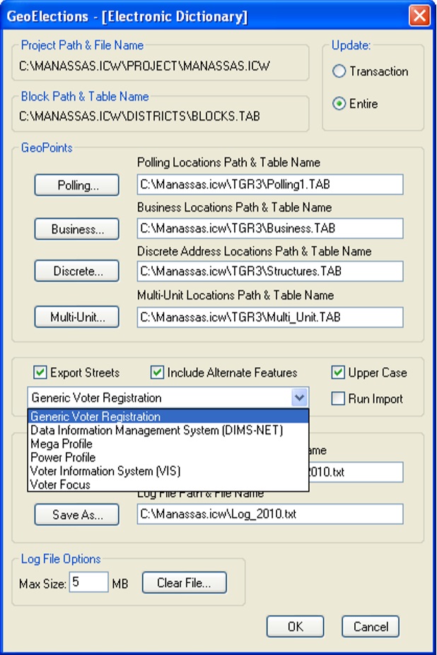
Using the GeoElections – [Electronic Dictionary] dialog box the user can select the data output that targets the unique demands of the voter registration system implemented in their jurisdiction.
Elections officials who have been in office through a decennial redistricting with responsibility to conduct an election following changes that impacted their jurisdiction, can appreciate the automation GeoElections® implements in the alternative to alternative methods involving manual data entry.
With over a decade of continued feature enhancements, today GeoElections supports multiple vendors and offers features that range from automated legal descriptions of precincts to election night reporting.
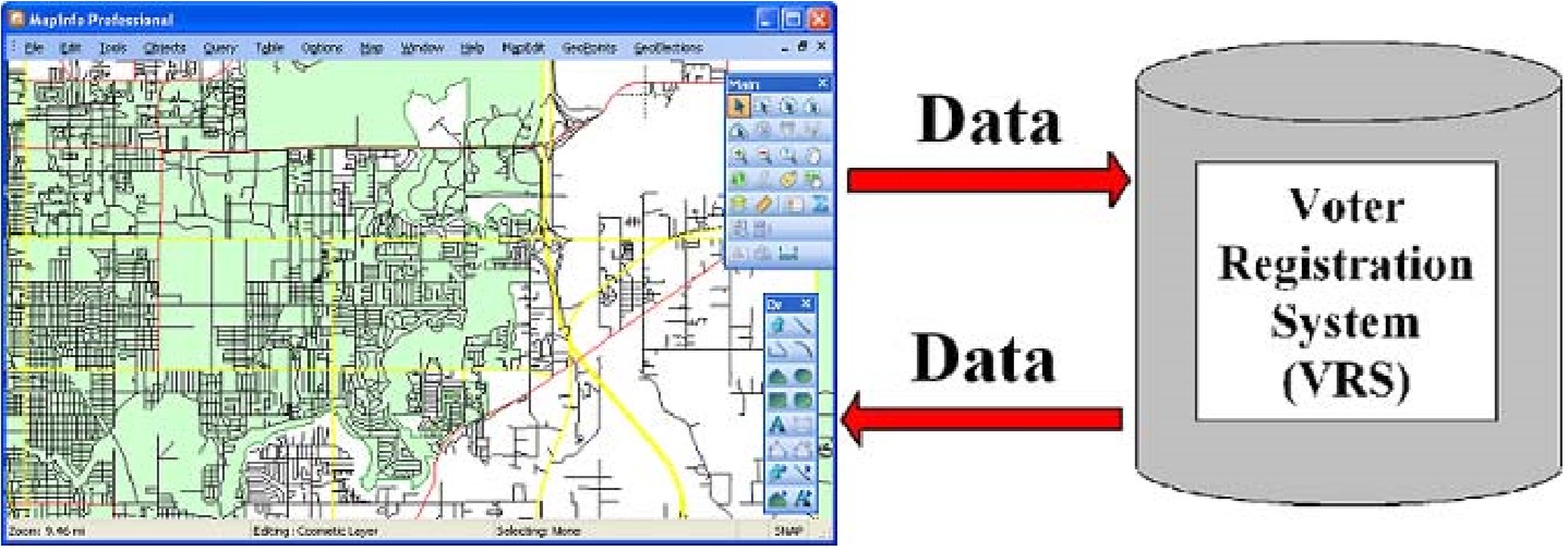
The data relationship between your VRS and GeoElections is a two way street. The VRS can provide the following data for use within GeoElections:
1. The Get Voters function in GeoElections pulls a voter file from the VRS as a native MapInfo TAB format ready for geocoding with GeoElections. With the voters geocoded, one can run a standard query to identify any voters that have been assigned to the wrong precinct. If there are errors, the results give the analyst an opportunity to investigate and make the necessary corrections.
2. GeoElections will tabulate the number of geocoded voters in each Census block. The Census blocks can be aggregated to create or modify precincts. As the analyst adds blocks, the system will increment the total  number of voters in a precinct and decrement the number of voters from the precinct to which the block was previously assigned allowing “what if” planning.
The combination of GeoElections with your VRS cannot be matched for accuracy and labor savings in meeting the demands placed upon your office. Especially when time is critical and accuracy is not an option.
If your voter registration system is not in the list of specifically supported applications, contact your VR vendor and/or the people at ICW. Integration and interoperability GIS to VR is the leading edge of proven solutions for cost effective services to your constituents in voter registration.
Major Features Included In GeoElections®
- Specifically designed for elections with up to date features that make GeoElections® a uniquely positioned solution to assist you and your staff to better meet your management goals and objectives.
- Interoperability with your voter registration system eliminating manual data entry into street maintenance through this programmatic electronic data transfer from GeoElections®, GIS to street index with complete or transactional update options.
- The Paper Dictionary provides a bridge from GeoElections® to your voter registration system when you do not have a programmatic interface available for your voter registration system.
- GeoCoding Engine uses your map data to put your voters on your map.
- Editing TIGER/Line or Shape Files allow you to use the same data your state legislature will use for redistricting, the P.L. 94-171 data.
- Legal Descriptions in terse, medium or verbose provide walking instructions that define precincts, wards and other jurisdictional boundaries as required.
- Calculates and creates maps of precinct splits for inspection and redesign. Tabulates voters to census blocks for use with redistricting to assemble blocks into precincts. The reprecincting module provides the user with the number of voters in a precinct as blocks are assigned to a precinct simultaneously displaying the decrement of precincts from which blocks are being reallocated.
- WebElection™ publishes and archives results to the web, provides high resolution precinct level interactive maps along with traditional web based reports for the viewing public. After reviewing an existing implementation of WebElection™ and you find one or more features you would like to include, please contact the people at ICW to discuss feature enhancements. We build software to meet your needs. Your suggestions just may be the feature others are likewise looking for inclusion for their administrative election night and archival needs.
- GeoPackager builds a menu interface for distributing your data (streets, precincts, polling sites, congressional districts, and others) with a free map viewer all of which runs off distribution CD’s or copied to local disk to run at the speed of the local computer.
- Image Maker generates jpg, tiff, gif, etc. files of polling location maps for use on websites, sample ballot mailers, or maps to meet statutory reporting to accompany legal descriptions.
For more information visit http://www.icwmaps.com and browse the catalog of GeoElections® News or select Products & Services to read about GeoElections® and obtain more detailed product specifications.
The above is a brief listing of some of the features offered with GeoElections®. Items not listed or described in greater detail include DOJ Reporter, MapMaker, Election Night Reporting with WebElections™ and more.

 "It all begins with the Map!"
 Temple Terrace, FL
  $.50
$.50