 "It all begins with the Map!"
GeoElections News
 Temple Terrace, FL www.icwmaps.com VOL. 8 NO.2 -
  $.50
$.50 
|
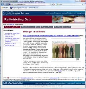
www.census.gov/rdo The Census Redistricting Data Office (RDO) has published a website, listed above. This is an excellent portal through which anyone interested in accessing the P.L. 94-171 data can obtain both the geography and demographics used by organizations performing redistricting across the country.
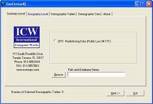
In addition to providing a convenient portal to the data, the people at the RDO have created numerous documents and programs accessible via the Tech Tips tab. As stated at the top of the Tech Tips page you will find, “Tools to assist you when working with the 2010 Census [P.L. 94-171] Summary File data.” This data is also available for use with GeoCensusIQ® the newest version of which is featured in the adjacent story. The P.L. 94-171 data is distributed with GeoCensusIQ®. GeoCensusIQ® GeoCensusIQ® provides the user with an easy method for linking the demographic data from the US Bureau of the Census with maps. For 2011 GeoCensusIQ® works with the P.L. 94-171 files from the US Bureau of the Census linking the data with numerous levels of geography including blocks, block groups, tract, VTD, place and county all generated from the US Bureau of the Census TIGER/Line Files. GeoCensusIQ® facilitates ease-of-use and rapid access to all of the demographic variables contained in the P.L. 94-171 databases from the Bureau for analysis using MapInfo Professional. GeoCensusIQ® presents the user with a single dialog box with multiple tabs which guide the user step-by-step through the process of linking user selected demographics with the targeted map.
The Summary File 1 (SF1) data is expected before the end of August 2011 which will be added to GeoCensusIQ®. There will not be a Summary File 3 (SF3) for this decade. That information will only be gathered through the American Community Survey (ACS). |
Ohio GeoElections Training June 23 and 24, 2011 A GeoElections class is being planned to follow the Ohio Secretary of State’s Summer conference. This class will run for one and a half days and will cover topics ranging from project setup, update your VR, to use of the election reporting system. This is a unique opportunity to learn about GeoElections for all users from experienced to new. From answers to questions to feature demonstrations, there is something for all. Meet your counter parts from across the state, other BOE staff members who are also working with GeoElections. For more information contact ICW at the number listed below. Renaissance Columbus Downtown Hotel, 50 North 3rd Street, Columbus, Ohio 43215 Invitation to Speak at Pitney Bowes Business Insight Annual Conference “Working With 2010 Census Geography In Elections”
Ken Tozier has been invited to deliver a presentation at the PBBI Insights 2011 User Conference focusing upon the use of Census geography and GeoElections to address the efforts of elections officials. GeoElections was first introduced in 1998. The people at ICW believed the product would serve county elections officials through 2002 when timeliness and accuracy of massive updates to voter registration databases following state legislative redistricting results were of the greatest importance. Following the initial deployment of GeoElections, ICW clients proved they knew better than the developers and upon realizing the benefits of interoperability between GeoElections and their voter registration systems, stated they wanted to continue using the application. A decade later ICW has implemented feature enhancements largely driven by client request. Today, GeoElections operating within the MapInfo Professional application environment brings the same ease-of-use to clients originally offered. But, with the addition of over a decade of experience and feature enhancements, all of which add up to represent a robust vertical integration of GIS and elections management from voter registration to election night reporting. New GeoElections WebTools ICW rewrote WebTools, eliminating the need for ASV. WebTools runs in multiple browsers including MS IE, Firefox, Chrome, and Safari. GeoElections WebTools provides election officials with the power to offer voters access to election data via interactive maps on the World Wide Web. Designed for ease-of-use and strategically positioned to combine the wealth of election data with the need to educate current and future voters. School districts can bring WebTools into their classroom with state specific lesson plans. Election information comes alive with this rich graphical presentation to capture the spirit and encourage an action to participate as an informed elector like never before. With GeoElections WebTools, citizens can obtain sample ballots specific to their household, find their polling place then print pictures and maps. Candidates can print precinct maps with which to conduct their campaigns. There is a great economy afforded to the elections office when using this web based delivery service. |