 "It all begins with the Map!"
GeoElections News
 Temple Terrace, FL www.icwmaps.com VOL. 9 NO.2 -
  $.50
$.50 
|
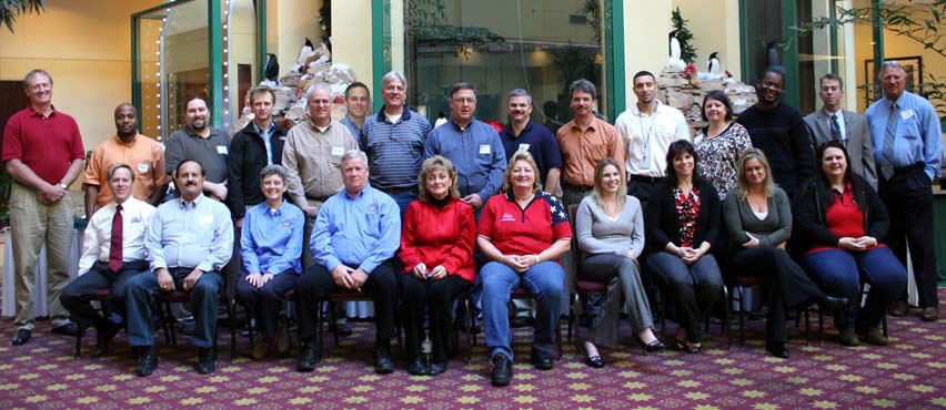
Another Annual GeoElections User’s Conference – Number 11 With redistricting, reprecincting, and a Presidential election now completed, the attendees at our 11th Annual GeoElections Conference enjoyed a unique combination of workshops and presentations. The attendees were engaged in discussions relating to their experiences working with Census Geography, the VTD program, and what actions might be taken to improve on these outstanding programs. Catherine Clark McCully, Chief of US Census Redistricting Data Office and Assistant Chief, James Whitehorne spoke about the 2010 Census Redistricting Data Programs with a view towards the future 2020 Census. They explained the view from the Bureau and solicited input from all of the attendees going forward.
John Guthrie, Staff Director of the Florida Senate Reapportionment Committee, presented “View from Florida: How can we make Phase 2, BAS, and reprecincting easier and better for 2020?” In eleven years of conducting our Annual GeoElections Conference, this was the first time we have had the privilege to host a collegial exchange of ideas involving highly informed representatives from county, state, and federal levels of government. All of these attendees are motivated stake holders in a positive and productive outcome to the issues of redistricting. While references were made to 2020, there are numerous events like milestones throughout the decade that represent opportunities at all three levels of government to work collaboratively to create success. For our attendees, these milestones began at the conference with the opportunity to provide feedback to state and federal policy recommenders along with an honest and open exchange between our state and federal participants. Two of the most detailed issues discussed centered on the Boundary and Annex Survey (BAS) and concepts for census block geometry. While our county attendees were very knowledgeable of census blocks and the importance of the role they play in precinct formation and with the PL 94-171 data their importance in redistricting, information pertaining to the BAS was new and promises to be a productive opportunity for improving municipal boundaries within their respective counties. To that end it is noteworthy to underscore the high degree of interest our county attendees expressed in contacting their local government BAS participants to become familiar with the problems these people face and ascertain how the elections office may be able to work with the BAS participants to create the most accurate data feasible for return to the US Bureau of the Census. Discussion was held amongst the attendees of the possibility of conducting a summer workshop with US Census BAS representatives to develop a further understanding of the role our elections offices may be able to play in BAS data programs similar to the VTD project this same group participated in during 2008-09. |
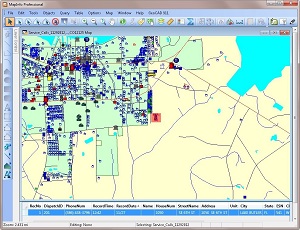
ICW Awarded Major E911 Project With Approved Grant Funding From Florida 911 Board - Can Benefit Elections Offices In Same County 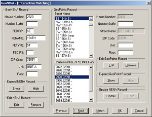 Now alongside the standard character based workstations mounted upon the 911 dispatcher’s or call taker’s position, ICW has created the means to map the origin of the 911 call, permitting the professional to see the location, surrounding vicinity, and dispatch the appropriate level of response be it police, fire, or EMT. In the case of the first deployment of GeoCAD 911™, the county maintains the 911 database of street names and addresses to which telephone numbers are linked. Using GeoAuthor® and GeoPoints©, the staff was able to create a precise map containing street center lines and a table of structures. Both GIS databases contain the proper street spelling, addresses, and ZIP codes. Using ICW’s GeoNENA® software, the client was able to match the 911 database file with the GeoPoints© database, correct exceptions, and generate a report with which the telecom vendor was able to correct their addresses. With the 911 database scrubbed, a base map of features and structures, the 911 Coordinator was ready to define the view contained in the auxiliary map display. Once this view is determined, Because GeoCAD 911™ operates within the MapInfo Professional® environment, the call taker or dispatcher has tremendous control over the map with the interactive tools including but not limit to:
GeoCADD 911™ puts geospatial software in the hands of professionals to leverage their critical skills. |